Geotagging Your Photos with GeoLogTag
As many of you may know, iPhoto '09 includes a feature to capture and display geotagged photos. The photo sharing site Flickr.com does the same thing. Geotagging photos is great for travelers who want to keep track of the location of where their photos were taken. Some cameras include features for automatically geotagging photos, and there are also camera accessories that help get the job done as well. Photographer and writer Derrick Story wrote a very useful article that outlines "Four tools that automatically capture location data while you shoot," so I won't rehash that information here.
But say you don't want to spend a lot of extra money to geotag your photos, but you would like to do it on your next vacation. Well, as the popular saying goes, there's an app for that. It's called GeoLogtag, developed by Chris Cornelis of Galarina. By snycrhonizing the time zones and specific time on both your camera and your iPhone, you can keep a log of where your photos were taken, and then later you can use the GeoLogtag app to stamp your photos with the GPS metadata collected on your iPhone.
Now the workflow for doing this geotagging is not something you're going to look forward to each time you go out and shoot photos. As you might imagine, GeoLogtag has its limitations. First off, you have to keep the app open in order to use it while you're shooting. While you can close out the application and restart when you need it, the app must be opened and started if you want to capture the location and timing of your shots.
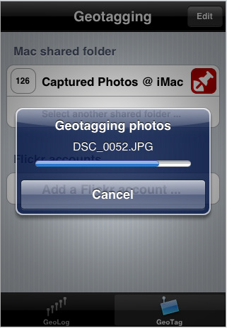
When it comes time to sync your data with your photos, that process also requires a few extra steps in your workflow . You must first import your photos to a shared public folder on your computer. GeoLogtag will sync with your shared folder and go through the process of tagging your photos. How much time it takes to tag your photos depends on how large the files are. In my trial runs, I didn't find it a speedy process. But it does work.
Once you've tagged your photos, you can proceed to import them into your favorite photo processing application, such as iPhoto or Aperture, where the tagged data will be retained with each photo.
Flickr.com Tagging
GeoLogtag will also tag your logged photos on your Flickr photostream, which in turn enables you to view your tagged photos on your Flickr map page. I found process for tagging my logged Flickr-uploaded photos to be faster than the process for tagging them in my shared folder. Part of the reason this process is faster is because the GeoLogtag app doesn't embed the synochrized data on the photos itself. It just embeds the information into your account and links to photos logged by the GeoLogtag app.
After you add your Flickr account to the GeoLogtag application, you give GeoLogtag permission "to modify photo properties (latitude and longitude) on your Flickr account." The procedure is really easy to setup.
With both procedures for tagging photos in your shared folder or on your on Flickr account, GeoLogtag lets you know how many photos will be tagged and when the process is completed. The visual progress bar that shows up during the is process is also helpful, especially for when the application hits a snag as it did a few times when I used it.
Room for Growth
As I've pointed out earlier, you may not look forward to using GeoLogtag. The workflow is a little time consuming, and it app doesn't work with RAW images, but if you're an avid photographer who wants or needs this GPS feature, I would recommend having this app on your iPhone.
I really think with time and continued work by the developer, this application will grow. Perhaps when the technology advances on the iPhone for applications to run in the background, GeoLogtag will be more useful and easier to work with. The developer might also find a way to sync data directly between the app and photos imported into iPhoto or Aperture, thus avoiding the process of importing them first into a shared folder on your Mac.
Also, and ironically, because GeoLogtag cannot be ran in the background, you cannot geotag iPhone camera photos with this app. I'm pretty sure Apple will provide that feature in future upgrades of the iPhone, but at least the developer of GeoLogtag has paved the way for that feature.
So despite its shortcomings, I applaud the work that has been done to produce GeoLogtag, and I look forward to it's growth. Support this developer with a $4.99 download (iTunes Store link.)
PhototoMac
Galarina has also recently released another app, PhototoMac (iTunes Store link) that enables you to wirelessly transfer photos in your iPhone camera roll to a networked folder on your Mac. This process requires a Wi-Fi connection and that you be in range of your networked computer. The process for setting up the connection is really easy, and if you're like me, it will save you the hassle of having to wire your iPhone to your computer just so you can import a few iPhone camera photos.
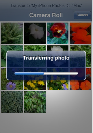
There are a few drawbacks, however. You can only transfer one photo at a time, and the procedure can only be done with photos on your iPhone camera roll. You can't select and transfer photos from your iPhone photo library that you say imported from your iPhoto library onto your iPhone. In similar iPhone camera roll related apps, you can select multiple photos for certain procedures, so I'm sure that the developer will be able to add this ability in future updates of PhototoMac. Also, as the developer points out, "Because of a limitation in the iPhone SDK, the transferred photos contain no EXIF information (and therefor also no GPS/location information.)"
Despite these drawbacks, PhototoMac is another feature that Apple should have built into the iPhone by default. Almost anything that can be done wirelessly gets a big 5+ rating from me. I mean, just think about it. When you select a photo on your iPhone camera roll, why shouldn't you have the option of sending it wirelessly to a folder in on your computer or directly to say iPhoto or Aperture? Camera roll photos can be emailed or posted to your MobileMe gallery, so why not go one step further? Well, again Galarina has paved the way for that.
Apple, get this developer on your team!
 del.icio.us
 Digg
Digg Facebook
 Slashdot
 StumbleUpon

Comments
GeoLogTag turns your iPhone into a GPS data logger with geotagging capabilities. While shooting photos with your digital camera GeoLogTag continuously tracks your location just like a traditional GPS data logger. You can track locations for 12 hours with an iPhone 4. It’s also possible to track a location every 3, 5, 10 or 60 minutes to prolong battery life. This is so amazing! I totally like this feature. ReputationAdvocate